A glider is limited in how far it can fly by its glide ratio. The glide ratio is determined by its lift, divided by its drag, or l/d.
But is a gliders ability to fly great distances limited by simple physics? Yes, and, no. But you have to now factor in:
Earth Energy
Earth energy creates a dynamic atmosphere that can extend a gliders flight beyond the limits of glide slope. In simplistic terms, The physics of the gliders flight through dead still air, are altered by the physics of the airs motion around them.
Lift and Sink
What goes up, must come down. With a glider, once you reach release altitude your plane is always going down, in relationship to the air it is in. However, with modern gliders that have a low minimum sink, and a high l/d, the glider can climb when the air it is in rises faster then the gliders glide slope brings it down. As air heats over a large parking lot, the air rises. We may observe discarded trash bags lift off the ground and spiral upwards. This is the birth of a thermal, a narrow column of rising air. As the hot air rises, it cools, and descends. This makes the atmosphere dynamic, able to be harnessed and used.
Lift and sink are created by multiple sources, but follow the same rules, what goes up, must come down. Whenever there is lift, there is sink.
A glider pilot will fly slower, closer to minimum sink speed in strong lifting air, and fly faster then best l/d through strong sinking air. No matter the lift source, you climb faster at near minimum sink speed, and, to get through sink faster to reach next lift source, you fly faster. While flying locally, you will stay near best l/d only slightly above to get out of strong sink. When flying cross country however you use McCready theory. Your sailplane will be equipped with a McCready ring, or, a computerized MC setting in a more advanced variometer.
Variometer and McCready
McCready rings, or setting on variomters are used to set the lift you experience and expect to find again, and determine the best speed to fly though the sink to reach lift again and cover the most distance in the best time.
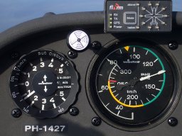
How A Variometer Works
A variometer is a very sensitive version of the vertical climb indicator found in other planes.
A variometer is a simple, yet sensitive instrument. There are other types of compensated variometers, but for understanding the basics, a variometer contains a diaphragm that receives a direct source of the static pressure. The surrounding chamber has a reference pressure that is allowed to leak back into the static system at a calibrated rate. As the pressure increases, or decreases in the diaphragm as compared to the surrounding pressure, the needle on the dial is moved to indicate the difference. Gliders may often have more then 1 variometer, some calibrated to indicate whether the air around them is rising or falling, regardless of if the glider is climbing or diving.
Causes Of Lift And Sink
The atmosphere is dynamic, it is rarely dead still. So lets look at what makes it rise and fall. What allows a glider to fly beyond best glide ratio, or climb as high as a jet might fly.
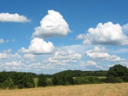
Ground Heating Thermals And Cumulus Clouds

Cumulus clouds are a great indication of thermal activity. When areas of the ground head faster then the surrounding areas, rising columns of lift are created. A glider pilot will circle in these rising columns to gain altitude. Exactly as a hawk or eagle would. In fact, if hawks are seen flying, there is usually lift. Look for them, circle with them, and you are likely to have a great flight.
Darker areas, rocky or paved areas, heat up much faster then moist forests or wetlands. Often thermals exist, in the absence of the telltale cumulus clouds. On these "blue lift" days, you need to look to the ground for areas that are likely to produce thermals. Many gliderports might have a "home thermal" an area that has slightly more dependable lift, like a quarry. Over the years soaring local glider pilots know where the most likely lift might be, and are worth consulting before attempting longer flights.
Cumulus clouds form, when and if moisture is carried to where the air has cooled to the dewpoint, and it condenses into a cloud. Cumulus clouds are born, they mature they die and they decay. At times they can even overbuild into the mighty cumulonimbus, the thunderstorm capable of spawning tornadoes.
Recognizing the stage of the cumulus will improve your chances of finding lift, sink, or just turbulence. What starts with a wisp ends with a wisp, at this point, unless your pretty attuned to watching the motion of the faintest mist, you'll likely have trouble telling birth from death. Over several minutes it will either begin to take shape or start to fade away.
Cumulus Lifecycle
This timelapse shows the birth, building, mature, and dissipating stages of the complete lifecycle
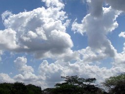
Cumulus Building Stage
The building stage is most recognizable for having good thermal energy feeding its growth. You can see a well developed top, and the underside has a slight concave appearance, you can almost visualize the energy pushing up into it, depositing moisture along the way. The 2 clouds in the center are most likely building the strongest, while the 1 to the right might still be working, but is mature headed towards decay. The cloud on the left has lost distinction, top and bottom, and is in decay.
It is important here to note that a thermal under the cumulus would be slanted by the wind, and some thermals are fed by bubbles of rising air rather then columns. In this case, a glider above, and even one below might be in lift, in rising bubbles, while a 3rd between them not have any lift at all.
Cumulus Dissipating Stage

Notice the contrast to the previous example. The cumulus front and center has a upper surface that's less distinct, almost appears to be collapsing on itself, and the lower surface is convex, the edges are falling apart. This cumulus will likely have nothing but sink. Instead of condensing the moisture is dissipating and he cloud will slowly fade from existence.
There will be nothing but cool sinking air under this cloud, all of it's energy lost.
Building and decay is a part of every thermal, and every cumulus's life cycle. A cumulus that keeps building without signs of decay can overbuild into the mighty cumulonimbus, and become dangerous indeed!
Mature Cumulus Stage
A Mature cumulus may still produce strong lift, it is characteristic often by being taller, and wider then an early building cumulus. The underside may still be concave or slightly more flat. The upper edges are still well defined, but not as much as he building stage.
As a mature thermal transitions to dissipating lift and sink can form turbulence under the cloud. Climbing at that point is difficult, but not impossible.
Mature cumulus clouds are at their peak of development, and soon will lead to decay and dissipation.
The cumulus can build beyond the cumulus stage, and become the great cumulonimbus.
Cumulonimbus Development Stage
When cumulus clouds are fed lots of energy, and moisture, they can become towering cumulonimbus clouds. A skilled glider pilot can often pint to a cloud and say that cloud has the potential to overdevelop into a thunderstorm long before the top reaches a height that causes the distinctive anvil shaped top. In the case of the cumulonimbus there is very strong energy feeding it, it starts to dissipate downwind in that high altitude anvil, with rain, strong downdrafts and often very strong turbulence. Gliders can soar under cumulonimbus clouds in thunderstorms, but it is risky, and often terrifying. Updrafts exist that are strong enough to suck you into the clouds where you get disorientated having lost sight of the ground, and you can be pulled up higher then your oxygen system allows for. There can be equally violent downdrafts, wind shifts, and in some cases even tornado activity. Many glider pilots can estimate how long it might take to overdevelop, and use the powerful lift prior to that point to climb quickly. For the novice to intermediate glider pilot, it is best to avoid the entire area where a cumulus might develop into a cumulonimbus. A cumulus that will develop into a cu-nim (for short) might be surrounded by other cumulus clouds that will become a more widespread overbuilding.
Cloud watching
Time spent watching clouds, in particular cumulus and storm system development can be a valuable pastime when not actively flying. The greater your understanding of the lifecycle of thermals and cumulus clouds, the more proficient you become at finding lift under them.
The Mighty Wind
While a variometer measures minute changes in air pressure within a thermal, large scale pressure zones can also form fueled by heating and cooling. High pressure air tries to flow into low pressure air to equalize he pressure causing wind. This is why the low pressure at the eye of a hurricane or tornado can determine the strength of the winds flowing around it. Wind speed is determined by the pressure gradient between 2 air masses.
Wind becomes lift when it encounters an obstruction that deflects it upwards.
Wind Over Mountains
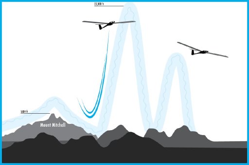
When wind flows over a mountain range perpendicular to the ridge, it has nowhere to go but up. In the example to the left, 3 gliders should be pictured to best illustrate what happens.
The ridge that originally altered the motion of the air would provide strong ridge lift, a glider could fly somewhat low, but fast, and close to the ridge for very long distances.
On just the right day, with all the right conditions, downwind of the ridge standing waves may form, some theoretically into the stratosphere. In these mountain waves a glider can soar higher then a jet, without thousands of pounds of thrust to get you there.
Ridge Lift
Wen the wind passes over a mountain ridge, at a near perpendicular angle, it flows up and over the mountain, rising on the upwind side, and sinking on the downwind. The lift and sink near mountains can be very strong, allowing high speeds near the ridge tops. The sink downwind can be equally strong, so crossing over ridges takes planning and extra altitude.
When atmospheric conditions are just right, the rise and sink of the air over the ridge triggers a standing wave.
Wave Lift
The wave that forms downwind of a mountain range can go higher then any plane can fly. In fact, The Perlan II space glider hopes to do just that. Soar a wave to 90,000 feet!
Waves are incredibly silky smooth lift that takes you straight up, as high as you dare go. High altitude flight in gliders takes skill and training. When you fly very high, your never exceed speed, as indicated on your air speed indicator, is significantly reduced. Therefore you may be near redline speeds, but think your flying much slower. Higher altitude flying also requires different oxygen systems.
Weak Lift Sources
There will be times when you only need 100 feet to get on a glide slope to home, where even the weakest lift will matter between getting home and landing in a field.
Slope Lift
When the suns been heating a slope all day the morning hours might produce a weak lift on the east side, and on the west towards late afternoon. A glider might not be able to climb in such weak lift, but instead reduce its sink just enough to matter.
Frontal Lift
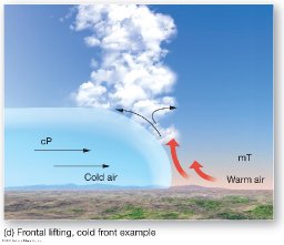
The location, speed and direction of frontal movements are perhaps the easiest to predict a weak, yet dependable lift. While the wind over a ridge might die enough to stop producing lift. A massive air mass on the move is not likely to stop unpredictably.
If a frontal line forms along your course to home, it's weak lift just might be enough to get you there, after all the thermals have died, and the ridges and waves have stopped working, you can look to weak lift sources to get you home safely.
Shore Lift
Water and land heat, and cool at very different rates. Land will heat up faster, and cool down faster then water. Early in the morning the water maybe significantly warmer then the air, and rise just off shore, while later in the day the ,land maybe alot warmer then the water, and provide lift closer to the shore.The greater the temperature difference, the better the chances of lift being generated.
Harnessing Earth Energy
Normally when you think of harnessing earth energy, you think of solar panels converting sunlight into electricity, wind turbines converting wind into electricity, geothermal, tidal and wave generators. Harnessing the energy to generate electricity.
Gliders instead use the energy, as is. The earth converts solar energy into thermals we use as fuel to gain height, which we convert into distance and speed. Wind does not need to be converted to energy, just deflected by features of the earth upwards. Geothermal refers to heat coming from the earth being converted to steam then electricity. Gliders use the energy produced by a dark field being a few degrees warmer then a nearby forest.
Gliders are extremely efficient at using the energy produced by the sun and the earth without conversion. Except to altitude, and to speed.
--
soaringeagle
head dreadhead at dreadlocks site
glider pilot student with freedoms wings international soaring for people with disabilities
updated by @soaringeagle: 04/30/18 07:27:29PM